


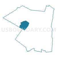
Voting District 010002, Ulster County, New York
About
Outline

Summary
| Unique Area Identifier | 638081 |
| Name | Voting District 010002 |
| County | Ulster County |
| State | New York |
| Area (square miles) | 43.43 |
| Land Area (square miles) | 43.42 |
| Water Area (square miles) | 0.01 |
| % of Land Area | 99.98 |
| % of Water Area | 0.02 |
| Latitude of the Internal Point | 41.93891850 |
| Longtitude of the Internal Point | -74.43395570 |
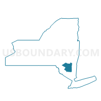
Maps

Graphs
Select a template below for downloading or customizing gragh for Voting District 010002, Ulster County, New York


Neighbors
Neighoring Voting District (by Name) Neighboring Voting District on the Map
- Voting District 010001, Ulster County, NY
- Voting District 120001-120005, Ulster County, NY
- Voting District 120004, Sullivan County, NY
- Voting District 140002, Ulster County, NY
- Voting District 140003, Ulster County, NY
- Voting District 170001-170004, Ulster County, NY
- Voting District 200007, Ulster County, NY
Top 10 Neighboring County Subdivision (by Population) Neighboring County Subdivision on the Map
- Wawarsing town, Ulster County, NY (13,157)
- Rochester town, Ulster County, NY (7,313)
- Olive town, Ulster County, NY (4,419)
- Neversink town, Sullivan County, NY (3,557)
- Shandaken town, Ulster County, NY (3,085)
- Denning town, Ulster County, NY (551)
Top 10 Neighboring Unified School District (by Population) Neighboring Unified School District on the Map
- Rondout Valley Central School District, NY (16,868)
- Onteora Central School District, NY (15,372)
- Ellenville Central School District, NY (12,869)
- Tri-Valley Central School District, NY (6,402)
Top 10 Neighboring State Legislative District Lower Chamber (by Population) Neighboring State Legislative District Lower Chamber on the Map
- Assembly District 98, NY (138,734)
- Assembly District 101, NY (128,454)
- Assembly District 107, NY (125,994)
Top 10 Neighboring State Legislative District Upper Chamber (by Population) Neighboring State Legislative District Upper Chamber on the Map
Top 10 Neighboring 111th Congressional District (by Population) Neighboring 111th Congressional District on the Map
Top 10 Neighboring Census Tract (by Population) Neighboring Census Tract on the Map
- Census Tract 9550, Ulster County, NY (5,471)
- Census Tract 9510, Ulster County, NY (4,419)
- Census Tract 9501, Sullivan County, NY (3,557)
- Census Tract 9553, Ulster County, NY (2,539)
- Census Tract 9546, Ulster County, NY (1,722)
- Census Tract 9509, Ulster County, NY (1,335)
Top 10 Neighboring 5-Digit ZIP Code Tabulation Area (by Population) Neighboring 5-Digit ZIP Code Tabulation Area on the Map
- 12446, NY (5,061)
- 12458, NY (3,232)
- 12740, NY (1,886)
- 12461, NY (1,634)
- 12464, NY (1,020)
- 12494, NY (764)
- 12725, NY (277)